Wednesday, July 25, 2012

Cabot Trail

The Cabot Trail is a 185 mi circle tour of Cape Breton Island, Nova Scotia.      Altho it was named after the explorer, it is believed that he actually landed in Newfoundland in the 1400's.   This road was completed in 1932 and surprisingly, is open all year round.    
We are camped a bit west of the village of Baddeck at the southern end.  We started our trip counter-clockwise as we had heard that most do it the other way and also, we would be on the ocean (scenic)  side of the road.   But, being a Monday, we practically had the road to ourselves.  
One of the first sights is a view of Cape Smokey, a prominent outcropping that is visible along most of the eastern coast.   The road climbs to the top for wide ranging vistas.

One of our plans was to try a hike along the coast.    The weather was perfect except for the winds which made wearing a hat impossible.

We could see our destination off in the distance.....
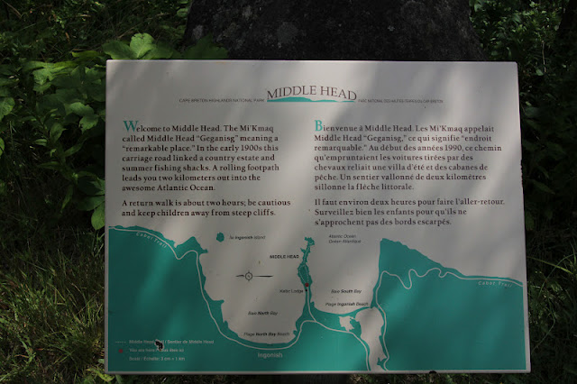
This signage below was very confusing to me as the land is in the aqua and the sea is white......

At 2.4 mi long and a recommended time of 1-2 hours, this seemed to be a very comfortable jaunt for us.
The sights around every corner were majestic....Cape Smokey in the distance.


At the end, it was a sheer cliff with no fencing ..... the water was crystal clear and we looked for whales but none appeared......
but many gulls diving for food......

The trail was not all smooth sailing......not sure what Paul is pointing at but it was the only good picture of the climb upwards .    We finished in a bit under two hours, including pondering life on some benches along the way.    Surprisingly, the strong winds on the trail were not as bad  at the point.....
We ended our stroll at the beautiful Keltic Lodge.   It is government owned and very appealing.   Reminded us a bit of the lodges at the national parks altho not as rustic.
Located on this peninsula is the historic  Highlands Links Golf Club
It has a significant slope rating and the staff said it was difficult but he also said that it was a course that   every golfer should play.   It is considered the #1 public golf course in Canada and has a significant history....check out the link for gorgeous views and info.    We are thinking about playing but the weather might not cooperate and then the weekend crowds fill it up.   But it's on my list of things to do .... someday.
This church is fairly typical of the anglican style.   The golf course winds around it.
Located within  the Cabot Trail is the Cape Breton Highlands National Park.    The Scottish influence is evident everywhere....from the gaelic signage to the tartan souvenirs.    Over 80% of Cape Breton Island is descended from the British Isles, and about 18% are French and reside on the western side.     We had only planned on doing half of the Trail but instead of retracing our steps, we just kept going around.....and then the skies darkened and the rain moved in.    This area is very dry and they welcome the rain.    It has rained heavily all night and is forecasted to be wet all of Tuesday.    I think there is a yarn shop waiting for me in Baddeck and then a good book.


Saturday, July 21, 2012

Moving on.........

We left the ferry rides behind and lumbered NE into Nova Scotia yesterday.   
 This is the only map that would download but wanted to give you a geography lesson.    Maine is a short drive SW from ST John on the left on the map.   We drove about 2 hours up to Moncton yesterday and then 2 hours south until we came to Truro.   Tomorrow we will drive another 4 hours or so up near the Cape Breton Highlands.     Truro is an agricultural area of rolling hills, cows, pine trees and proximity to fresh seafood.    Homes are   well tended with gardens and flowers.  

We headed out to the downtown Farmer's Market and it was so worth it.    The produce was fresh, abundant and colorful.....

 Of course, the bread was irresistible and I had to buy some strawberry/rhubarb homemade jam to go with it.   I almost succumbed to some hand knit sox since I only brought short cotton ones with me.  But then realized that if I concentrated for a couple of days, I could have my own hand knits since I brought an unfinished pair with me.  
Then we stopped at a unique market near our CG and fell into a fresh seafood lunch plus some warm-from-the-oven rolls to make sandwiches, using garden-grown tomatoes......No, we haven't had to buy new clothes to accommodate all the delicious food we've tried.   Actually, we eat out very little and watch what we eat at home and get our daily walks in..........but sometimes we fail.   


We're finding the Canadians to be very friendly, the weather is clear, dry and sunny, and perfect with a sweatshirt for our evening campfire.    Gas is about $4.25 a gallon and a bit more for diesel.   We found that they have COSTCO up here !!     And Wal Mart only has a few groceries and most everything is written in French/English.  

One other tidbit.....Nova Scotia is halfway between the North Pole and the Equator.....
And, we still have access to our Direct TV so we get our evening news same as always and we watched the British Open golf today.    We have internet at this CG and hopefully, at the next one.    
We're looking forward to exploring the Cabot Trail and the Cape Breton Highlands next week.    Stay tuned..........

Wednesday, July 18, 2012

Views from New Brunswick........

I'm a bit behind....with no onsite internet, we have to go find it locally to check the daily happenings in the outside world.    We are so plugged in that it is a bit like withdrawal but then I get used to not being connected and I forget about sharing with my loyal followers......  so it's catch up time and I've tried to give you a bird's eye view of our days here.    

In order to get to our CG, located on the hill, we need to cross the St. John River.   These ferries run year round 24 hours a day and are guided by a cable.     The grey building on the far side is the campsite office.

It was built in 1785 !!    After the Revolutionary War, there were about 14,000 who were still loyal to the King.....they came up here to begin new lives.    The Harding House was built by a member of Benedict Arnold's group.   I'm sitting in this building at the moment, writing this and looking at 230 year old beams above me.   
 St John's is a popular cruise stop for passengers wanting to view the Loyalist history and the remnants from The War of 1812 and see the Bay of Fundy.   This market
 has been active since about that time.....it is rich with sights and sounds...wonderful looking produce, fresh fish and crafts.    St John itself is rather decrepit but the area is very scenic.

Yesterday, with Dean and Diane, we headed over to the little coastal town of St Martins.    The Bay of Fundy has the highest tides in the world and this iconic picture of the lobster boats at low tide, is seen on postcards


 and paintings.    The tides are 15 meters and I have no idea how many feet that is but you can see the water line.
 Lobstering is a big industry here as well.
 This rocky area had no horizon due to the low clouds.....
 St Martins was a ship building center in the 1800's due to the heavily forested surrounding area.    There are a few of the large stately homes still standing.

Nearby is the Fundy Trail.....a 18 km (about 8 mi) trail that winds along the coastline.     We had the illusion that it would be relatively flat.....we were wrong.....but the part that we did was worth the huffing and puffing.    After I climbed down on tenuous steps  to see a waterfall, I realized that I would have to climb back up.....it was wiggly and lacked sure footing and not sure the scenery was worth it.  

 The trail alternated between heavily forested paths to
 views along the coast.  
 The fog drifted in and out.........
 I liked the bonus color along the way.......
 We stopped at the Interpretive center to learn about logging along the Big Salmon River....seen here at low tide.    The Hearst family owned much of the land and saw mills for their paper industry.   You can stay in his "rustic" log cabin.
 Dean and Paul on the trail.....
We ended the day with World Famous Chowder at a local seaside cafe...Our group gave it 5 stars.......

Saturday, July 14, 2012

Picture alert

We are currently near St John's New Brunswick, without WiFi at the campsite.....feels like we left half our brain behind....no quick references, no maps, no checking out future itinerary....no emails.....    But we managed to get thru the night and are currently in the CG office hooked in.....
Anyway, the point of this blog is to thank Rian for pointing out that the previous pic of the eagle flying off, seems to have prey in it's talons.    I blew up the picture and agree that it looks like a rabbit....!!    I am thrilled that I captured it but not surprised that I didn't recognize what the undercarriage of an eagle looks like when I previewed the pictures.    Do you think National Geographic wants to hire me now ????

We're out to explore this urban area / scenic coastal area and maybe even find a good breakfast.      Weather a bit humid but clear and nice.  

Friday, July 13, 2012

Sea kayaking

On a brilliantly gorgeous day, we headed to the ocean for a guided kayak tour.    Altho we have kayaked before, we've only enjoyed it in placid rivers or broad lakes.   There was a stiff breeze with some white caps on the bay and we set out with 6 others and a guide.    The young couple who own this enterprise are enthusiastic and helpful and we wish them well in their 15 year old business......try Machias Bay Kayak Tours if you're in the area.    
After battling the wind and sea spray for longer than my arms wanted, about 70 min or so (time has no meaning when the wind and waves seem endless).....we came to a beach on Hog Island.      I had hoped to 
take pictures as we skimmed along the bay but my camera stayed safely dry in a bag and we got pretty soaked....we did have the kayak skirts on and that helped to keep us dry on the lower half.   In this picture below, you can see the distant hills....this is where we started.  In this bay, the US Navy began with the first naval battle of the Revolution.   This area is rich with Revolutionary History....from houses, to taverns, to ships to trails.  
These rust colored areas look like painted rocks......on closer examination are these petroglyphs.  
This one is a man with an antler head dress of sorts.   Various experts have examined them but there is no definitive on who or when.....sometime after the Ice Age they say which is a pretty broad time frame.    There were others scattered about as well.
After a nice break and a snack, we got ready to depart when an eagle dropped out of the sky onto a nearby pine.    It was quite stunning.


I didn't get a good shot of it flying off but the wing span was impressive.  

Along the route, we skirted rock islands with seals lounging in the sun....not having a camera, I have no proof of that......until this one popped up his head near the shore while we relaxed.  

 It was a fun trip and a highlight of our time on the coast.....today we are feeling fine with no residual aches in case you were wondering.   But next time, I might check the wind and the whitecaps before I head out into it.   And yes, the return trip was much smoother, MUCH faster and much drier.      And more lobster awaited us at the end of the day.....

Today, we load up the wagon and  reluctantly leave this scenic area and head farther northeast into Canada.